Fox-Wolf Watershed Alliance is implementing conservation projects to protect our waters for future generations. Help us prioritize future restoration projects and strengthen funding requests by telling us how you enjoy the lakes!

Please be specific – we are interested in the areas you use the most (we are looking to improve your spots, not steal them!). The map will be made public but your name will not be tied to the points you add.

To get started, please click the button “Take the Survey Now!” or use the QR Code on the right.

Once on the map, click the “Edit” icon located on the upper left corner underneath the search bar. The icon looks like a list with a pencil. Select the type of activity that you would like to add, then click on the map where you do this activity to add it.

Add as many points as you’d like, keeping in mind we are interested in the areas most important to YOU. Adding an area that covers a whole lake is not as helpful as adding three points of the areas you fish the most and the boat launch you use to access it.

If you enjoy our waters in a way not listed, please select the most similar activity or select “other”, and add a description of the activity in the notes.

Thank you for your help and participation!

Contact Katie R with any questions or concerns at katherine@fwwa.org

Winnebago Waterways is a Fox-Wolf Watershed Alliance recovery initiative. Contact us at wwinfo@fwwa.org

The post Tell us where and how you use the waterways! appeared first on Fox-Wolf Watershed Alliance.

Original Article

Fox-Wolf Watershed Alliance

Fox-Wolf Watershed Alliance

https://fwwa.org/2024/01/15/recreationsurvey/?utm_source=rss&utm_medium=rss&utm_campaign=recreationsurvey

Katie Reed

Project Overview

In 2020, the Wisconsin Department of Natural Resources (WDNR) developed a Total Maximum Daily Load (TMDL) for the Upper Fox and Wolf River (UFW).  A TMDL is a calculation of the maximum amount of a pollutant that a body of water can absorb and still meet water quality.  The TMDL was utilized in the creation of the EPA’s Nine Key Elements (9KE). Within the 9KE there is a requirement for reductions in pollution to meet water quality goals.  The goals within this plan are to reduce Total Phosphorus (TP) which also relates to the reduction of Total Suspended Solids (TSS) such as erosion and flooding.

Approximately 34% of the reduction from the TMDL needs to come from the Winnebago Waterways Recovery Area with 51% of that reduction assigned to agriculture.  Alteration in farming practices and structural changes will help make reductions.

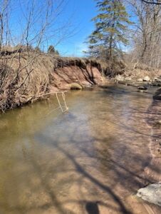
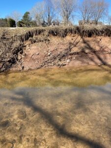
Currently, a missing piece in the TMDL and draft 9KE plan is streambank erosion. Streambank erosion is lumped in with agricultural loading estimates and required reductions in the TMDL. In some watersheds, we anticipate streambank erosion being a significant contributor to the total TMDL agricultural load. We need to inventory the streambanks in each HUC12 so that we can estimate potential TP/TSS reductions that could come from stabilizing streambanks to stop streambank erosion and to prioritize project locations. Stabilizing streambanks would be paired with efforts to increase infiltration on the land to reduce the volume and rate of flow that damages streambanks during storm events.

For this project, we will begin by completing streambank inventories in the four highest loading HUC12s located within the WWRA. The pollutant load from these HUC12s significantly contributes to water quality impairments of the streams within each HUC12, the Winnebago Lakes, and Lake Michigan. In addition to providing loading estimates from streambank erosion, this project also seeks to identify and prioritize potential locations for future restoration projects to help reduce nutrient loading and protect or enhance existing habitat. Going forward, this project will serve as a template for completing future streambank inventories for the remaining 28 HUC12s located in the WWRA.

Target HUC12 Subwatersheds in the 2023 Streambank Erosion Inventory

HUC12 to be Inventoried                                HUC12 Code                                Stream Miles

Town of Dale-Rat River                                      040202022102                                         60

Eldorado Marsh-Fond Du Lac River                 040302020204                                         63

Lake Poygan – Willow Creek                             040302022006                                          88

Pipe Creek – Frontal Lake Winnebago            040302020303                                          91

Project Timeline

In the Spring of 2023, a method was developed using GIS to determine streambanks to be physically inventoried as they are representative of the HUC12 they are located in. The method developed has been recorded in SOP#1: Streambank Erosion Inventory Desktop Review so it can be duplicated.

Fieldwork was accomplished in the summer of 2023. Streambank information from the desktop review was utilized to complete a physical inventory of these sections.

December 2023 – February 2024: Streambank Inventory Data Analysis was developed along with the extrapolation. These tools will allow an estimation of sediment loss and load & phosphorus loss and load for an entire watershed.

Project Funding & Partners

Winnebago Waterways is a Fox-Wolf Watershed Alliance recovery initiative. Contact us at wwinfo@fwwa.org

The post Prioritizing stabilization projects using streambank erosion inventories in the Fox-Wolf River Basin appeared first on Fox-Wolf Watershed Alliance.

Original Article

Fox-Wolf Watershed Alliance

Fox-Wolf Watershed Alliance

https://fwwa.org/2024/01/11/streambank-inventory/?utm_source=rss&utm_medium=rss&utm_campaign=streambank-inventory

Katie Reed

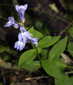
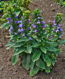
The species spotlighted this month is Great Blue Lobelia (Lobelia siphilitica)! Also known as Blue Cardinal Flower, Great Blue Lobelia is a perennial wildflower native to Wisconsin that grows well along streams, springs, swamps, meadows and other places with sufficient moisture. This species grows up to 4 feet tall, with a leafy stalk on which blue/purple tubular flowers bloom in July – October. Great Blue Lobelia requires moist to wet soil and partial to full sun, and is resistant to deer browsing. This plant has a wide distribution in North America, found in wet ground from Main to Colorado and into Canada, and south to North Carolina and Texas.

The seedlings of Great Blue Lobelia are very tiny at first, before growing into the clump forming wildflower. This plant usually blooms in its first year. Seeds in October – November and in optimal conditions, this plant may self-seed, but is not overly prolific. It is not very drought tolerant, and requires moist soil.

Great Blue Lobelia is a great plant for shoreline plantings. Along with other native species, its roots are great for capturing and slowing down stormwater runoff, and for holding on to soil which helps prevent erosion. In addition, Great Blue Lobelia attacks hummingbirds and native bee species!

Image Credit: Aaron Carlson; www.wisflora.herbarium.wisc.edu; CC BY-SA 3.0

H. Zell; CC BY-SA 3.0

Winnebago Waterways is a Fox-Wolf Watershed Alliance recovery initiative. Contact us at wwinfo@fwwa.org

The post Species Spotlight: Great Blue Lobelia appeared first on Fox-Wolf Watershed Alliance.

Original Article

Fox-Wolf Watershed Alliance

Fox-Wolf Watershed Alliance

https://fwwa.org/2023/10/27/species-spotlight-great-blue-lobelia/?utm_source=rss&utm_medium=rss&utm_campaign=species-spotlight-great-blue-lobelia

Katie Reed

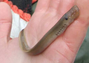
This month’s species spotlight shines light on a native lamprey species of the Winnebago System: Chestnut Lampreys (Ichthyomyzon castaneus). There are other native species of lamprey in the Winnebago System too. These are the Silver, American Brook, and Northern Brook lampreys. Chestnut and silver lampreys are parasitic as adults, feeding on fish. However, this usually does not kill the fish. Despite the scary looking sucker disks, native lampreys are an important part of the ecosystem.

Chesnut Lamprey (young) Photo Source: Cal Yonce/USFWS

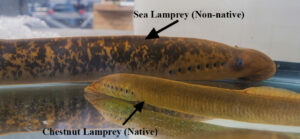
However, there is a non-native lamprey species to be aware of too: the sea lamprey. The sea lamprey is an aquatic invasive species has not invaded the Winnebago System, but is present in the Great Lakes. If the sea lamprey were to invade the Winnebago System, it is likely they would cause major issues for the ecosystem. We must work hard to keep this aquatic invasive species out of the Winnebago System. Though a bit creepy looking, the chestnut lamprey (and Silver, American Brook, and Northern Brook lampreys) are native to this region.

Chestnut lampreys are parasitic as adults but not as larvae. The adult chestnut lamprey attaches to a fish, then scrapes a hole in the body and sucks out blood and tissue fluids for nutrients. After feeding on a fish for several days, the lamprey drops off. Usually, the fish is not killed directly by the attack, but may die due to infections from the wound.

Chestnut lampreys have a skeleton made of cartilage with no true vertebrae. They technically do not have a jaw. This makes lampreys different from eels, which have a bony skeleton and jaws. Lamprey bodies are long and cylindrical. Chestnut lamprey adults range in length from 5-11 inches. The mouth of adult chestnut lampreys is as wide or wider than the head, and contains sharp teeth that each have two points (bicuspid). Along their back, chestnut lampreys have one continuous fin. Adults are usually dark brown, gray, or olive-green on the top, with a lighter coloration of yellow or tan on the stomach. During spawning, they can appear blue-black. Younger lampreys tend to be lighter in color.

The native range of the chestnut lamprey is as far north as the Hudson Bay in Canada and as far South as the Gulf of Mexico. The Mississippi and Missouri River networks help with this large range, as the lampreys move with their host fishes.

Chestnut Lamprey (bottom; native) vs. Sea Lamprey (top; non-native; NOT found in Lake Winnebago)

Photo Source: Bobbie Halchishak/USFWS

Chestnut lampreys spawn in late spring when the water temperature is about 50ۧ°F. Chestnut lampreys stay in the larval phase for 3 – 7 years. Chestnut lamprey larva do not have eyes. When they hatch, chestnut lampreys move downstream and bury themselves at the bottom of the water body they’re living in. For the next few years, they filter feed on tiny algae particles and tiny organisms before beginning to develop their sucking disk. This disk develops teeth which allows for parasitic feeding. Once Chestnut Lampreys are adults, they can suck blood and other nutrients from host fish. Chestnut lampreys can feed on many different fish species including carp, trout, pike, sturgeon, catfish, sunfish, and paddlefish. They live another one to two years as adults, for a total lifespan of about 6 – 9 years.

Chestnut lampreys are primarily nocturnal, meaning they are most active at night. This is often why we don’t see them unless they are attached to fish we catch! During the day, they rest under rocks and along river banks. Adult chestnut lampreys are not known to have predators, but the larval lampreys are preyed upon by burbot and brown trout.

Though we tend to think of parasites as “bad”, they play an important role in the ecosystem including helping to remove weaker fish from the population. The lamprey population may become large when they have plenty of fish to feed on, but then decrease as host populations decrease. This cycle is normal in the ecosystem. Aquatic invasive species like the sea lamprey are a cause for concern because they interfere with normal population dynamics.

Winnebago Waterways is a Fox-Wolf Watershed Alliance recovery initiative. Contact us at wwinfo@fwwa.org

The post Species Spotlight: Chestnut Lamprey appeared first on Fox-Wolf Watershed Alliance.

Original Article

Fox-Wolf Watershed Alliance

Fox-Wolf Watershed Alliance

https://fwwa.org/2023/08/25/species-spotlight-chestnut_lamprey/?utm_source=rss&utm_medium=rss&utm_campaign=species-spotlight-chestnut_lamprey

Katie Reed

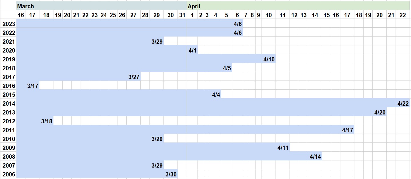
Ice out on Lake Winnebago was officially called by the Army Corps of Engineers on April 6, 2023 as determined by MODIS satellite imagery. Ice out (aka ice off) is when ALL ice is gone from the lake surface as observed by satellite.  This is important because ice out marks the date that the Army Corps transitions their management of Lake Winnebago from maintaining winter pool to focus on spring refill.

Ice out dates for Lake Winnebago 2006 to 2023 (Source: ACOE)

The Army Corps of Engineers – Chicago District manages water levels for Lake Winnebago by regulating outflow at the dams in Menasha and Neenah under the Federal Marshall Order of 1886. The Marshall Order is intended for flood risk management.

The Marshall Order defines the limits of regulation for Lake Winnebago:

  • May 1st to October 1st (navigation season):
    • High end of limit: 3.45 ft.
    • Low end of limit: 0.18 ft.
  • October 2nd to April 30th:
    • High end of limit: 3.45 ft.
    • Low end of limit: 1.68 ft

While meeting their mission of flood risk management is the priority, the Army Corps also tries to meet the needs of various stakeholders within their operating limits. This requires finding a reasonable balance among multiple competing interests. Each year, with stakeholder input, the Army Corps sets their annual regulation strategy which guides their daily management decisions.

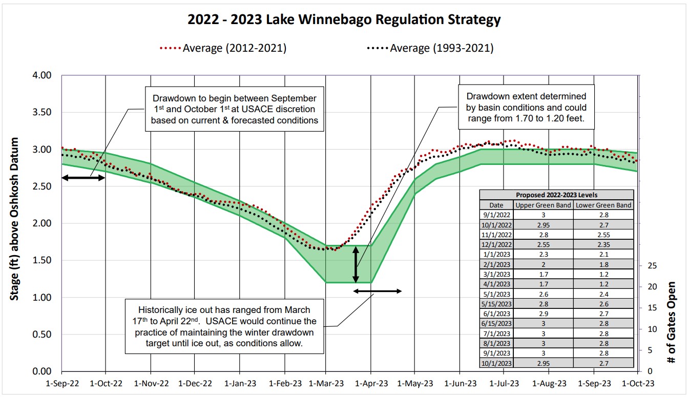
Their annual regulation strategy represents that balance and can be broken down by certain times of the year: fall drawdown, winter pool, spring refill, and summer pool. Water level targets are set along this strategy in a schedule. These targets are listed in the Army Corps 2022 – 2023 Lake Winnebago Regulation Strategy (shown in the image below). The green band in the annual strategy represents the “target band”. The Army Corps tries to hold water levels within this band. The dotted lines represents the average lake level across all years as noted in the key.

Average Water Level for Lake Winnebago

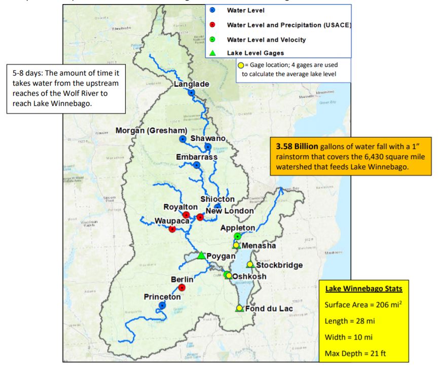
Lake level for Lake Winnebago is an average of readings from four gages located around the lake and is in reference to the Oshkosh Datum.

Fall Drawdown: As of the 2021/2022 regulation strategy, fall drawdown has been scheduled to begin between Sept 1 and Oct 1 each year at the discretion of the Army Corps through an adaptive decision making process.

Winter Pool: Each February, the Army Corps evaluates basin conditions and the forecast to determine their winter drawdown target.

The Army Corps draws down Lake Winnebago every winter to reduce the risk of damage caused by ice shoves, protect shoreline properties, and provide enough space within the lake to hold excess water that flows into Lake Winnebago each spring (snow melt and rain storm runoff from a 5,900 square mile watershed). The 2023 winter drawdown target operating band for Lake Winnebago this year was 1.25 ft to 1.3 ft.

Spring refill: When the Army Corps determines ice out has occurred on Lake Winnebago based on satellite imagery, spring refill is triggered. For many boaters, people interested in habitat protection, and stakeholders working to restore the lakes, refill is of particular interest. According to the most recent annual strategy, refill targets are as follows:

  • May 1st – 2.5 ft (Operating band: 2.4 to 3.6 ft)
  • June 1st – 2.8 ft (Operating band: 2.7 to 3.9 ft)
  • June 15th – 2.9 ft (Operating band: 2.8 to 3.0 ft)

Summer Pool: The Army Corps tries to maintain the lake within a target band for summer recreation navigation.

The total seasonal water elevation change is typically about 1.8 ft in a given year.

Recent conditions:

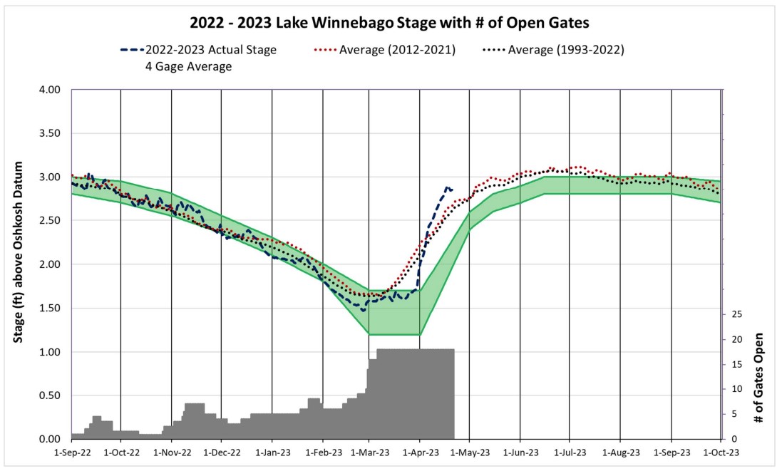
Despite having all available gates open at the dams since March 6, 2023, the average level of Lake Winnebago has been well above the target band since the beginning of April. This is likely due to the lake not being drawn down far enough or early enough to accommodate spring runoff from snow melt and precipitation. When inflows to Lake Winnebago exceed outflow capacity of the gates, the lake begins to rise uncontrolled. Overshooting the target band increases risk of flooding, significantly damages habitat and limits water quality restoration gains (among other impacts).

A graph from April 21, 2023 shows the recent average lake level (dashed line). Hopefully, precipitation will ease up and the Army Corps will be able to regain control before too much damage is done to the wetlands and aquatic habitat.

Additional Water Level Related Information:

1.) Water Level Management for the Winnebago Waterways: This report describes water level management including the process of developing an annual strategy, the considerations for the strategy, and the reason the strategy (schedule) is in its current form. CLICK HERE for the report.

This report is part of a larger planning effort for the Winnebago Lakes. The rest of the lake plan can be found here: https://fwwa.org/lake-management-planning-2/

2.) Winnebago Water Level Assessment Team (WWLAT): This is a stakeholder group that holds discussions about water levels independent of the Army Corps public input process. The website for the Team provides information about the background, past recommendations, and more. Interested stakeholders are welcome to participate. Link: https://fwwa.org/winnebago-waterways/wwlat/

3.) The Army Corps provides access to a lot of data and information through their Lake Winnebago webpage: CLICK HERE

Winnebago Waterways is a Fox-Wolf Watershed Alliance recovery initiative. Contact us at wwinfo@fwwa.org

The post Ice-Out officially called for Lake Winnebago – April 6, 2023 appeared first on Fox-Wolf Watershed Alliance.

Original Article

Fox-Wolf Watershed Alliance

Fox-Wolf Watershed Alliance

https://fwwa.org/2023/04/27/ice-out-officially-called-for-lake-winnebago-april-6-2023/?utm_source=rss&utm_medium=rss&utm_campaign=ice-out-officially-called-for-lake-winnebago-april-6-2023

Korin Doering