Fox-Wolf Watershed Alliance is implementing conservation projects to protect our waters for future generations. Help us prioritize future restoration projects and strengthen funding requests by telling us how you enjoy the lakes!

Please be specific – we are interested in the areas you use the most (we are looking to improve your spots, not steal them!). The map will be made public but your name will not be tied to the points you add.

To get started, please click the button “Take the Survey Now!” or use the QR Code on the right.

Once on the map, click the “Edit” icon located on the upper left corner underneath the search bar. The icon looks like a list with a pencil. Select the type of activity that you would like to add, then click on the map where you do this activity to add it.

Add as many points as you’d like, keeping in mind we are interested in the areas most important to YOU. Adding an area that covers a whole lake is not as helpful as adding three points of the areas you fish the most and the boat launch you use to access it.

If you enjoy our waters in a way not listed, please select the most similar activity or select “other”, and add a description of the activity in the notes.

Thank you for your help and participation!

Contact Katie R with any questions or concerns at katherine@fwwa.org

Winnebago Waterways is a Fox-Wolf Watershed Alliance recovery initiative. Contact us at wwinfo@fwwa.org

The post Tell us where and how you use the waterways! appeared first on Fox-Wolf Watershed Alliance.

Original Article

Fox-Wolf Watershed Alliance

Fox-Wolf Watershed Alliance

https://fwwa.org/2024/01/15/recreationsurvey/?utm_source=rss&utm_medium=rss&utm_campaign=recreationsurvey

Katie Reed

Project Overview

In 2020, the Wisconsin Department of Natural Resources (WDNR) developed a Total Maximum Daily Load (TMDL) for the Upper Fox and Wolf River (UFW).  A TMDL is a calculation of the maximum amount of a pollutant that a body of water can absorb and still meet water quality.  The TMDL was utilized in the creation of the EPA’s Nine Key Elements (9KE). Within the 9KE there is a requirement for reductions in pollution to meet water quality goals.  The goals within this plan are to reduce Total Phosphorus (TP) which also relates to the reduction of Total Suspended Solids (TSS) such as erosion and flooding.

Approximately 34% of the reduction from the TMDL needs to come from the Winnebago Waterways Recovery Area with 51% of that reduction assigned to agriculture.  Alteration in farming practices and structural changes will help make reductions.

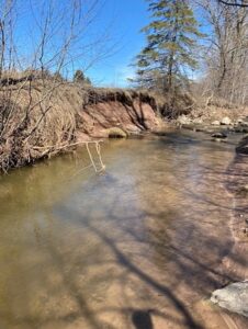
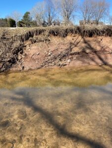
Currently, a missing piece in the TMDL and draft 9KE plan is streambank erosion. Streambank erosion is lumped in with agricultural loading estimates and required reductions in the TMDL. In some watersheds, we anticipate streambank erosion being a significant contributor to the total TMDL agricultural load. We need to inventory the streambanks in each HUC12 so that we can estimate potential TP/TSS reductions that could come from stabilizing streambanks to stop streambank erosion and to prioritize project locations. Stabilizing streambanks would be paired with efforts to increase infiltration on the land to reduce the volume and rate of flow that damages streambanks during storm events.

For this project, we will begin by completing streambank inventories in the four highest loading HUC12s located within the WWRA. The pollutant load from these HUC12s significantly contributes to water quality impairments of the streams within each HUC12, the Winnebago Lakes, and Lake Michigan. In addition to providing loading estimates from streambank erosion, this project also seeks to identify and prioritize potential locations for future restoration projects to help reduce nutrient loading and protect or enhance existing habitat. Going forward, this project will serve as a template for completing future streambank inventories for the remaining 28 HUC12s located in the WWRA.

Target HUC12 Subwatersheds in the 2023 Streambank Erosion Inventory

HUC12 to be Inventoried                                HUC12 Code                                Stream Miles

Town of Dale-Rat River                                      040202022102                                         60

Eldorado Marsh-Fond Du Lac River                 040302020204                                         63

Lake Poygan – Willow Creek                             040302022006                                          88

Pipe Creek – Frontal Lake Winnebago            040302020303                                          91

Project Timeline

In the Spring of 2023, a method was developed using GIS to determine streambanks to be physically inventoried as they are representative of the HUC12 they are located in. The method developed has been recorded in SOP#1: Streambank Erosion Inventory Desktop Review so it can be duplicated.

Fieldwork was accomplished in the summer of 2023. Streambank information from the desktop review was utilized to complete a physical inventory of these sections.

December 2023 – February 2024: Streambank Inventory Data Analysis was developed along with the extrapolation. These tools will allow an estimation of sediment loss and load & phosphorus loss and load for an entire watershed.

Project Funding & Partners

Winnebago Waterways is a Fox-Wolf Watershed Alliance recovery initiative. Contact us at wwinfo@fwwa.org

The post Prioritizing stabilization projects using streambank erosion inventories in the Fox-Wolf River Basin appeared first on Fox-Wolf Watershed Alliance.

Original Article

Fox-Wolf Watershed Alliance

Fox-Wolf Watershed Alliance

https://fwwa.org/2024/01/11/streambank-inventory/?utm_source=rss&utm_medium=rss&utm_campaign=streambank-inventory

Katie Reed