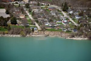
Floods can be devastating for anyone who experiences one. Flooding impacts can be even more intense, however, for vulnerable populations. That includes people who live in poor housing conditions, lack transportation options, or possess limited English skills that would hamper their understanding of emergency messages.

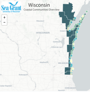
Through funding announced June 23 by the National Sea Grant Office (NSGO), Wisconsin Sea Grant is working with nine communities in northeastern Wisconsin to strengthen their resilience to flooding events by looking at who lives in the most flood-prone areas of a city. Wisconsin Sea Grant is partnering with the Bay-Lake Regional Planning Commission and Wisconsin Emergency Management on this effort.

In addition to the Wisconsin project, the NSGO and National Oceanic and Atmospheric Administration (NOAA) Disaster Preparedness Program are funding two other disaster preparedness projects in Hawaii and Massachusetts. (Find more details about those projects here.)

Work on the new project, which begins this month and continues through summer 2024, builds upon earlier Sea Grant-supported work using the Flood Resilience Scorecard. The scorecard is a comprehensive tool that helps communities look at their level of flood preparedness through a variety of dimensions.

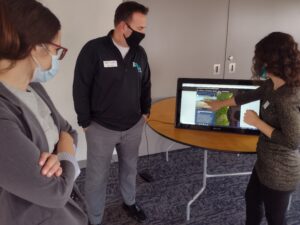
The Bay-Lake Regional Planning Commission demonstrates its virtual site explorer at the Northeast Wisconsin Coastal Resiliency Open House in Manitowoc. (Photo: Adam Bechle, Wisconsin Sea Grant)

Jackson Parr, a Sea Grant staff member who served as the J. Philip Keillor Flood Resilience-Wisconsin Sea Grant Fellow from April 2021 to May 2022, will be a key player in this new effort. He worked extensively with the Flood Resilience Scorecard and Wisconsin communities during his fellowship, drawing on his dual master’s degrees in public affairs and water resources management.

While Parr’s fellowship work included both coastal and inland communities around the state, the new project will focus more specifically on the Lake Michigan coast from Sheboygan County northwards.

Parr will work with Wisconsin Sea Grant Assistant Director for Extension David A. Hart and Coastal Engineering Specialist Adam Bechle, as well as staff at the Bay-Lake Regional Planning Commission, including Environmental Planner Adam Christensen.

Said Parr of his fellowship period, “Over the last year, I’ve worked with 16 communities…and we’ve identified some common gaps across all communities in terms of flood preparedness and flood resilience.” He found that no community had used spatial GIS technology to pinpoint where priority populations—those most vulnerable to flooding—live.

This kind of detailed, granular analysis can lay the groundwork for keeping people safer, especially because two places very close to one another can have very different flood risk. Yet doing this GIS work can be challenging to communities for a variety of reasons, such as a lack of resources or administrative capacity.

Said Parr, “These communities are doing a lot of good work in addressing some disparities, just not related to flooding specifically, because that gets into a narrower area than most communities have the capacity to do.” That makes the technical assistance offered by the newly funded project a welcome addition to what communities are already doing.

In addition to the GIS work, other aspects of the funded project include running the Extreme Event game in the communities. The game was developed by the National Academy of Sciences. Explained Parr, “It’s a scenario of a storm event, and random things happen throughout the scenario, and participants have to think how they’d respond. Then they do back-end reflection on that process.”

Game participants will include local officials and emergency management staff, but can also include residents who want to learn more about disaster preparedness and resilience in their community.

Said Christensen of the Bay-Lake Regional Planning Commission, “We’ll assist in outreach efforts to communities about participating in the game, screen for underrepresented communities in those areas, contact necessary stakeholders, attain Extreme Event Facilitator Certification to facilitate the games and provide local knowledge and mapping services for the team.”

Staff from Wisconsin Emergency Management will also get training in running the games, so they can do them in any Wisconsin community, giving the project a reach beyond the nine cities that are its main focus.

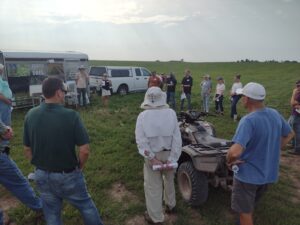
Participants in an East River Collaborative field trip learn about nature-based agricultural practices that slow down runoff and can help lessen flooding and improve water quality in downstream communities like the city of Green Bay. (Photo: Adam Bechle, Wisconsin Sea Grant)

A third outcome of the project will be implementing what’s known as the Plan Integration for Resilience Scorecard for participating communities. That assessment analyzes the variety of plans a community might have—from transportation to downtown revitalization to parks and recreation, for example—and helps them create consistent recommendations for floodplain management and disaster preparedness.

That helps avoid situations such as having one plan saying an emergency shelter should be located in a particular neighborhood, while another document prohibits that from a zoning angle, offered Parr as an example.

Taken together, the three main components of the project will help northeastern Wisconsin communities be better prepared to face challenges that may come their way, especially in a “perfect storm” event in which high Great Lakes water levels and extreme precipitation combine to cause significant flooding.

When asked about the biggest benefit of this project, said Christensen, “To me, the biggest benefit is the word ‘preparedness’—preparedness so that, when an extreme event occurs, the participating communities will be ready to react in an effective and efficient manner that saves lives.”

For more information about the project, contact Jackson Parr at jgparr@wisc.edu.

The post Disaster preparedness project in northeastern Wisconsin will build on earlier flood resilience work first appeared on Wisconsin Sea Grant.

Original Article

News Releases | Wisconsin Sea Grant

News Releases | Wisconsin Sea Grant

https://www.seagrant.wisc.edu/news/disaster-preparedness-project-in-northeastern-wisconsin-will-build-on-earlier-flood-resilience-work/?utm_source=rss&utm_medium=rss&utm_campaign=disaster-preparedness-project-in-northeastern-wisconsin-will-build-on-earlier-flood-resilience-work

Jennifer Smith

Lydia Salus grew up about 20 miles from Lake Michigan, in a Wisconsin village graced with Mammoth Spring, where water seeps through cracks on top of the shallow aquifer that underlies much of Waukesha County.

Since her formative years, water has been a part of Salus’s life. As an undergraduate, Salus worked on a project to facilitate fish passage through urban culverts. She got a master’s degree in water resources management with a focus on hydrology from the University of Wisconsin-Madison with the intention of becoming a hydrologist devoted to ecological restoration.

Although that career in restoration shifted in 2018 when she signed on as an assistant to the Southeastern Wisconsin Coastal Resilience Project, Salus remains tied to water. Right now, her connection is through a brand-new initiative to increase coastal resilience on Wisconsin’s Lake Michigan shoreline.

The new project builds on the previous one, which assisted people in Kenosha, Racine, Milwaukee and Ozaukee counties in responding to rising lake levels—offering information on how to stabilize bluffs, address erosion and protect infrastructure.

Aerial photo of water and buildings near the water. One house is balanced on the edge of a tall bluff over the water.

A southeastern Wisconsin house teeters on the edge of a bluff after coastal storms and waves eroded the shoreline 40 feet in four years. This house was later demolished

It was also notable for encouraging conversation and cooperation among the whole mix of lakefront property owners—between private property holders and municipalities, counties, state agencies and federal partners.

Termed Collaborative Action for Lake Michigan (CALM) Coastal Resilience, the project places Salus at Sea Grant. The Wisconsin Coastal Management Program and State Cartographer’s Office are the other members of this three-way partnership that, according to Salus, increases capacity to reach and serve communities. 

“The Southeastern Wisconsin Resiliency project was a really good start for taking a regional approach to addressing hazards. Hazards don’t just go away,” she said. “That earlier project was good at building momentum in those communities, so then we just wanted to expand that up the coast to other communities and share that momentum with them.”

CALM is funded by what Salus termed “an exciting grant; a competitive grant for something called a project of special merit” from the National Oceanic and Atmospheric Administration and which was awarded to the Wisconsin Coastal Management Program. It will strive for three outcomes:

  • Increasing collaboration across all stakeholders.
  • Developing, revising or adopting local ordinances, plans or policies that are going to help build resilience in coastal communities.
  • Fostering regional prioritization of hazards that need to be addressed so that when opportunities for collaborative action are available, community leaders are ready to capitalize.

CALM is a nearly $250,000 18-month undertaking that kicked off in October 2021 and will conclude in March 2023, making it, as Salus said, “A quick turnaround, but we already have a good framework to build off of. I think it’s a little bit easier to implement because we have something that we know worked (with the Southeastern Wisconsin Coastal Resiliency Project).”

When fully in the swing of the initiative, Salus will organize field trips, pandemic willing, to highlight coastal challenges and solutions. Additionally, she will host meetings to share case studies and tools, and support communities talking with each other and determining regional priorities. Those communities include 11 counties, 18 cities, 16 villages and 36 towns stretching from the state’s border with Illinois up the Lake Michigan coastline to the state of Michigan.

map of Wisconsin with communities along Lake Michigan highlighted in greens and blues to show areas involved in new resilience program.

Wisconsin’s Lake Michigan communities will participate in a new program to build resilience in the face of flooding, erosion and infrastructure damage.

The types of folks involved are those housed in state and federal agencies, local and state elected officials, coastal engineers and landscape professionals, municipal technical staff members, people from academic institutions, sewerage districts and regional planning commissions.

Salus said she is feeling energized by the chance to bring together so many people through a process that embraces “stakeholder-driven prioritization. I really like that term because we have built into the project the process of getting feedback from the communities. We are starting off with a survey of their needs, so we are then presenting tools and resources and bringing in speakers that are going to be helpful to them.”

Salus is also feeling personally energized as this new initiative gets underway, saying she appreciates the “unique challenge that balances the human-environment interaction. There are naturally occurring processes on the lake that wouldn’t necessarily cause issues if we didn’t have a built environment along the lake, if we didn’t have people living there.” She said she looks forward to the applied science that can address these coastal hazards that are certainly not going to disappear.


The post CALM aims to bring calm to communities facing coastal hazards first appeared on Wisconsin Sea Grant.

Original Article

News Releases | Wisconsin Sea Grant

News Releases | Wisconsin Sea Grant

https://www.seagrant.wisc.edu/news/calm-aims-to-bring-calm-to-communities-facing-coastal-hazards/?utm_source=rss&utm_medium=rss&utm_campaign=calm-aims-to-bring-calm-to-communities-facing-coastal-hazards

Moira Harrington

For Nicole Ward, Wisconsin Sea Grant’s current J. Philip Keillor Great Lakes Fellow, returning to Madison for this opportunity has brought her academic journey full circle.

Keillor Fellow Dr. Nicole K. Ward (Submitted photo)

Ward earned her bachelor’s degree in biology from the University of Wisconsin-Madison just over a decade ago, then left the Badger State for graduate studies in Idaho and Virginia. Yet Ward was eager to get back to the Upper Midwest and work on Great Lakes topics—making the Keillor Fellowship, which began June 1, an excellent fit for the newly minted Ph.D.

She is based at the Wisconsin Department of Natural Resources (DNR) Office of Great Waters, where she works closely with Madeline Magee, monitoring program coordinator, and Cherie Hagen, the Lake Superior Basin supervisor. Ward is also active in the Great Lakes Working Group of the Wisconsin Initiative on Climate Change Impacts (WICCI).

Broadly speaking, her focus is on incorporating climate change resilience planning into the DNR’s Great Lakes projects. The three main projects she’s associated with are:

  • The WICCI Great Lakes Working Group report, expected to be published online in late September. The report summarizes climate change effects on Great Lakes ecosystems and covers some potential solutions.
  • Great Lakes coastal wetlands: assessing the condition and resiliency of Wisconsin’s coastal wetlands in the face of climate change. This, in turn, could inform the prioritization of wetlands for restoration or protection.
  • Developing climate adaptation resources and information for DNR Office of Great Waters staff to ensure climate resiliency is built into all projects involving the Great Lakes and Mississippi River.

The range of duties draws upon Ward’s passion for freshwater ecosystems, but also allows her to grow her skillset. “I’ve worked in multiple other types of freshwater ecosystems, like rivers, streams, lakes and reservoirs, but this will add to my repertoire through working on the Great Lakes and coastal wetlands,” she said.

Nicole K. Ward explores some of Wisconsin’s waters by canoe. (Photo: Titus Seilheimer)

A native of Rochester, Minnesota, Ward spent three years with the Minnesota DNR working on native mussels and stream ecology after earning her bachelor’s degree.

Those years with the Minnesota DNR set her future direction in motion: “It was while snorkeling and scuba diving in the streams and rivers of Minnesota that I began seeing the effects of land management and decision-making that were far removed from the stream itself,” she said. “I had an ‘aha moment’ while working there, when I decided I needed to learn more about how people make environmental decisions, and how those decisions may change in response to changing ecosystems. The ever-changing and complex Great Lakes Basin is really the perfect place to apply my skills in understanding feedbacks between ecosystem change and human decision-making.”

After a master’s degree at the University of Idaho in water resources, doctoral work in biological sciences at Virginia Tech followed. There, she examined land use and climate change over the course of 31 years in the Lake Sunapee watershed in New Hampshire.

During her time at Virginia Tech, she also worked with a local lake association to co-produce an online, interactive data visualization tool for communicating with landowners about lawn management practices. She collaborated with a social psychologist to develop the tool and gauge its effectiveness.

This points to another area of interest: science communication and finding effective strategies for connecting with varied audiences. One of the key things she learned from working with the psychologist, Ward said, was that “Simple messaging is better. While you see that in the literature, this experience was a really direct, personal reality check of just how simple you need to keep things if engaging with a particular audience for the first time about a topic.”

The human dimension of environmental decisions is a throughline in her work. Said Ward, “A foundational part of how I think about myself as a scientist is to fully recognize that people make environmental decisions based on much more than just scientific evidence. Water issues are never actually about the water, they’re about the underlying values and priorities of people, and people have more shared values than we often recognize.”

The post Keillor Fellow to integrate climate change planning into Great Lakes and coastal wetlands projects first appeared on Wisconsin Sea Grant.

Original Article

News Releases | Wisconsin Sea Grant

News Releases | Wisconsin Sea Grant

https://www.seagrant.wisc.edu/news/keillor-fellow-to-integrate-climate-change-planning-into-great-lakes-and-coastal-wetlands-projects/?utm_source=rss&utm_medium=rss&utm_campaign=keillor-fellow-to-integrate-climate-change-planning-into-great-lakes-and-coastal-wetlands-projects

Jennifer Smith