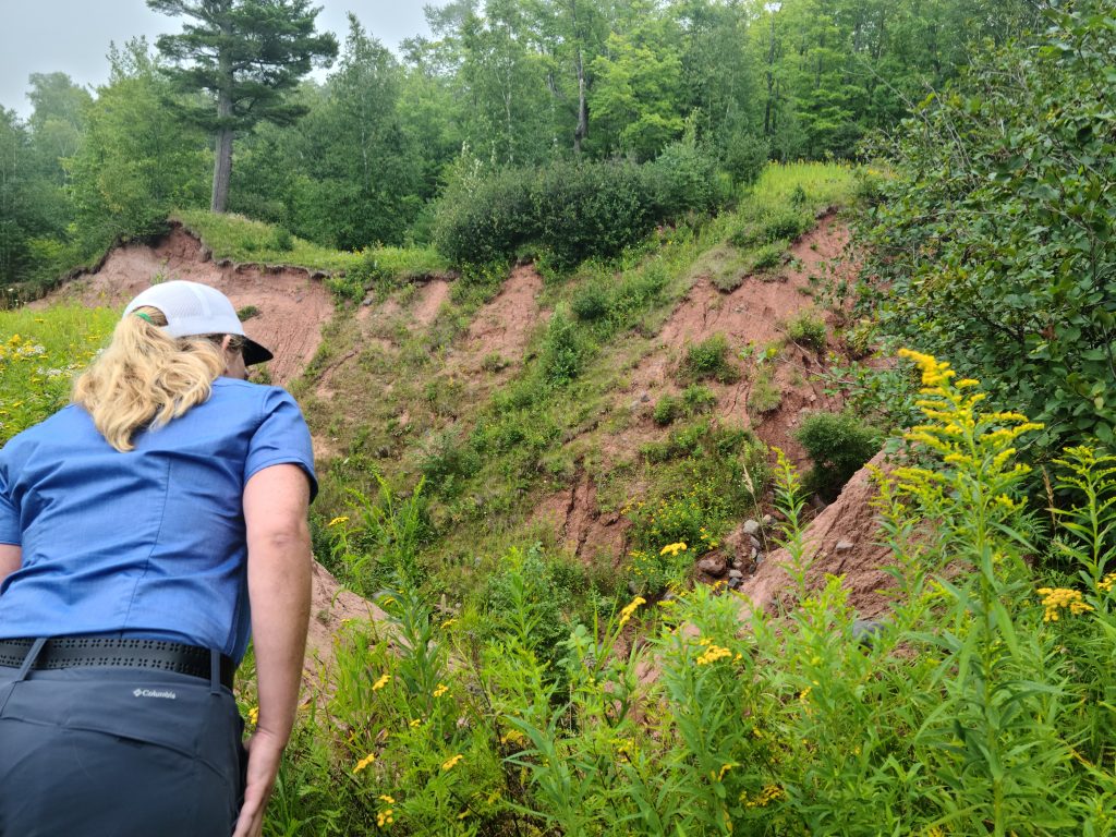
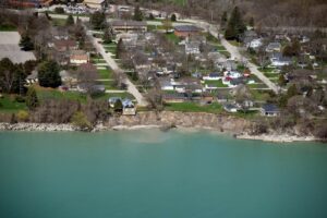
The calendar will soon flip to 2024. Our staff members are ready to tackle new projects in the coming months. Before they move more deeply into the new year, however, some staff members took a moment to retain the glow of their favorite 2023 project. Adam Bechle shared his thoughts. He’s our coastal engineering outreach specialist.

My favorite project for 2023 was helping organize a shipboard science workshop for educators in Milwaukee. Wisconsin Sea Grant’s Anne Moser and Ginny Carlton organized this annual professional learning opportunity through the Center for Great Lakes Literacy. This year, I was invited along to help bring a coastal engineering focus to the workshop.

The centerpiece of this workshop was two days aboard the R/V Neeskay, the research vessel of the UW-Milwaukee School of Freshwater Science. The Neeskay was an excellent platform from which to explore the coastal processes and engineering that shape Milwaukee’s lakefront.

Our itinerary was planned in close collaboration with the Neeskay’s Captain Max Morgan and the SFS’s Manager of Outreach Programs Liz Sutton. Our journey took us through three unique environments: the inner harbor, outer harbor and open Lake Michigan.

Adam Bechle instructs educators during the Shipboard Science Workshop in 2023. Image credit: Anne Moser

At each location, participants measured water quality, temperature and lake-bottom sediments. These observations helped us understand how waves, currents and other processes impact the three environments. We also got to see underwater video of the different habitats along the lakefront, which have been mapped on UW-Milwaukee’s Harbor Maps. This included a look at the species that inhabit Milwaukee’s “green breakwall,” which was designed to provide aquatic habitat benefits.

Back on land, we introduced the educators to a hands-on wave tank activity to take back home to their learners. In this activity, learners use a simple wave tank to explore how a sand beach responds to different waves and water levels. Learners then get to design, build and test a coastal structure to slow erosion. Using what they learned, several participants took a nature-based approach to their design.

This project was full of good things: A cohort of enthusiastic educators to work with; productive collaboration with great partners; two days of beautiful weather on Lake Michigan. I learned a lot about Milwaukee’s lakefront and left feeling energized about future work.

The post Shipboard Science Workshop earns “favorite project” status first appeared on Wisconsin Sea Grant.

Original Article

Blog | Wisconsin Sea Grant

Blog | Wisconsin Sea Grant

https://www.seagrant.wisc.edu/blog/shipboard-science-workshop-earns-favorite-project-status/

Adam Bechle

On Oct. 4, members of the Coastal Hazards of Superior (CHAOS) community of practice gathered atop a bluff overlooking Lake Superior to discuss the stability of the ground beneath their feet.

Coastal engineering specialist Adam Bechle discusses erosion with workshop participants on a cloudy day along Schafer Beach in Superior, WI.

Adam Bechle, center, discusses shoreline erosion with workshop participants along Schafer Beach. Photo: Cait Dettmann, Minnesota Sea Grant

The group brought together planners, zoning officials and individuals from local, state and federal government in both Minnesota and Wisconsin to share ideas and resources about coastal issues facing western Lake Superior. October’s meeting at Schafer Beach in Superior, Wisconsin, featured the debut of a new tool designed to document shoreline erosion, which threatens homes and other structures built atop bluffs.

Adam Bechle, coastal engineering outreach specialist with Wisconsin Sea Grant, and Hannah Paulson, the 2022–2023 J. Philip Keillor Coastal Management Fellow, developed the tool, which is a checklist that helps coastal property owners spot signs of erosion. It describes visual indicators like tilted trees and ground cracks and provides photos of each.

Said Bechle, “[It’s] a way to document what you see at the site. And if you’re a property owner, [it’s] something to refer back to and maybe do annually to look for signs of change.”

And atop a Great Lakes bluff, change is constant. Storms, wind, ice and wave action all impact how fast land erodes. High water levels, like the ones both Lake Superior and Lake Michigan have experienced in the past five years, exacerbate erosion and flooding.

Hannah Paulson holds up the erosion checklist and explains it to participants.

Hannah Paulson explains the erosion checklist. Photo: Cait Dettmann, Minnesota Sea Grant

Taking a longer look through history, lake levels have fluctuated even more drastically. Andy Breckenridge, a geology and environmental science professor at the University of Wisconsin-Superior who presented at the workshop, revealed that where participants stood atop the bluff used to be at the bottom of Lake Superior.

“Lake levels have been much higher than today, and they’ve been much lower than they’ve been today,” said Breckenridge. “And for that reason, this coastline has gone through dramatic changes. It has not looked like this for most of the last 12,000 years.”

With the long view in mind, CHAOS members snapped the erosion checklists to their clipboards and maneuvered down the bluff to give the tool a test run. Bechle and Paulson were joined by Todd Breiby and Lydia Salus of the Wisconsin Coastal Management Program, current Keillor Fellow Helena Tiedmann, Karina Heim of the Lake Superior National Estuarine Research Reserve and Madison Rodman of Minnesota Sea Grant in engaging CHAOS members about what they saw.

Tilted trees, a ground crack, lack of vegetation and a spot where groundwater was seeping through the bluff were some of the signs participants spotted. The activity sparked conversation about the importance of photos to explain erosion to property owners, with one participant noting the need for images of erosion after strong storm events.

A group of people in jackets and vests maneuver down a bluff along Lake Superior with clipboards in hand.

Workshop participants assess the bluff for signs of erosion. Photo credit: Wisconsin Sea Grant

Said Paulson, “I think we got some good suggestions for refining the tool even more.”

Returning to the top of the bluff, participants then cycled through three stations showcasing additional tools to assess bluff stability. One station showed how topography maps can be used to estimate slope—a helpful method if not physically on the property—and another demonstrated how to use an inclinometer to gather exact slope measurements on site. Participants also tried their hand at measuring the high point of the bluff using a reel tape.

While it may be tempting to frame erosion as the antagonist in this story, Bechle is careful to point out that without it, we wouldn’t have beautiful sand beaches, as much of that sand comes from eroded bluff soils. That’s why it’s important to make careful, informed decisions about if and where to build structures on bluffs and shorelines.

“Erosion is a natural process, and if we weren’t here, it would just be occurring,” said Bechle. “It’s not a bad thing; it’s just a bad thing because we have things we care about that might get impacted by it.”

Bechle and Paulson plan to include the checklist in an updated version of the “Coastal Processes Manual,” which is under development. In the meantime, coastal residents interested in maintaining and improving the stability of their bluff can refer to Wisconsin Sea Grant’s “A Property Owner’s Guide to Protecting Your Bluff.”

The post Convening CHAOS to spot signs of shoreline erosion   first appeared on Wisconsin Sea Grant.

Original Article

News Releases | Wisconsin Sea Grant

News Releases | Wisconsin Sea Grant

https://www.seagrant.wisc.edu/news/convening-chaos-to-spot-signs-of-shoreline-erosion/

Jenna Mertz

This home in Herbster, Wisconsin, was moved 150 feet back from an eroding Lake Superior bluff in 2003. Image credit: Marie Zhuikov, Wisconsin Sea Grant

The dynamics of land and water were on display for members of the Coastal Hazards of Superior (CHAOS) group when they toured Lake Superior’s South Shore at a homesite in Herbster, Wisconsin, last week. The home, now owned by Dan and Mary Schneider, was moved 20 years ago farther inland from an eroding lake bluff in one of the first efforts to address coastal home erosion and establish setback distances in Bayfield County.

Homeowner Dan Schneider shows CHAOS tour participants some eroding bluff east of his home. Image credit: Marie Zhuikov, Wisconsin Sea Grant

The tour was organized and led by CHAOS Coordinator Sarah Brown and Karina Heim, coastal training coordinator with the National Lake Superior Estuarine Research Reserve. It featured talks by homeowner Dan Schneider, Northland College Professor of Geoscience Tom Fitz, and Bayfield County Land Records Administrator Scott Galetka, who is also a member of Wisconsin Sea Grant’s Outreach and Education Committee.

I was one of the lucky tour participants along with Natalie Chin, Wisconsin Sea Grant’s climate and tourism outreach specialist.

Schneider, who has owned the 52-acre property since 2019, said he was happy to open his homesite for the tour. “The area’s got such an incredible geological history and cultural history, for us, it’s amazing to live here.”

He showed us where the house was originally situated, right on the edge of the 150-foot bluff. It now lies 150 feet farther back. The bluff was eroding from Lake Superior waves at the bottom and from stormwater runoff and groundwater flow at the top.

Moving the 3-bedroom home was a major undertaking. “They (the original owners) found a mover, but then they had to deal with the potable water supply, the electrical supply and the sanitary sewer,” Schneider said.

The spot where the house was moved to offered its own challenges in the form of shallow groundwater. Swales were installed along with drain tiles, ditches and a pond to keep the water from flowing into the house.

This is the bluff overlooking Lake Superior that was the original site of the home. Image credit: Marie Zhuikov, Wisconsin Sea Grant

Schneider said that not much erosion had occurred on the bluff since the home was moved, but that a bluff east of the house had been eroding actively. We walked about 200 feet in that direction for a view. Dirt and gravel tumbled down the slopes, which were bare of vegetation.

Fitz explained that the slopes were composed of clay and sand, remnants of the last stages of glaciation about 14,000 years ago. “There’s contact between clay of the Miller Creek Formation and sand from the Copper Falls Formation about 15 feet down,” Fitz said. “That contact is probably playing an important role in the stability of this bluff – or rather, the instability.” This sand-clay interaction characterizes much of the geology of Lake Superior’s South Shore.

Geology in action — a tour participant peers down into an eroding bluff on the Schneider property. Image credit: Marie Zhuikov, Wisconsin Sea Grant

Fitz described how groundwater was moving along the top of the clay layer and coming out of the side of the bluff, forming erosion. “What we see here is obvious evidence of the power of moving water,” he said, citing clay around the house for the groundwater issues that Schneider has noticed there.

“What we have here is a big, ‘wow.’ Geology in action,” Fitz said.

The good news is that Schneider’s house is safe from erosion thanks to its current setback from the bluff. The bad news is that the eastern ravine is eroding.

Schneider said that when he purchased the property, he noticed the erosion in the ravine, but it didn’t bother him. “I knew in my lifetime I wouldn’t need to worry about it. The privilege of living out here was worth it,” he said.

Back at a picnic table near the original bluff, we heard from Galetka, who explained how Bayfield County tracks coastal land changes over time. One of the ways he currently uses is a drone equipped with a 35 mm camera.

“I began this job in 2007. I’ve seen this program of setbacks and the importance of making sure we have science backing up where homes should go behind the bluff,” Galetka said. “This was the site that sparked everything. It was kind of like the poster child.”

CHAOS Coordinator Sarah Brown (left) and Wisconsin Sea Grant Climate and Tourism Outreach Specialist, Natalie Chin (right) look at photos of the home-moving process with Northland College Geoscience Professor Tom Fitz. Bayfield County Land Records Administrator Scott Galetka is in the background. Image credit: Marie Zhuikov, Wisconsin Sea Grant

The wind was too stiff for Galetka to demonstrate his drone, but that allowed us to have a close look as it rested on the picnic table. He said that technology has advanced greatly since the home was originally moved and that data sets are much more accurate now.

We came away from the tour with a greater appreciation for the intricacies involved in how land and water interact, and admiration for the forethought required to preserve a beautiful Lake Superior home.

For more information about coastal erosion along the South Shore and to hear from Jane Bucy, the original owner of the Schneider home, about the house-moving process, you can watch a YouTube video of the CHAOS group’s June 2022 meeting.

The post Visiting the house that sparked coastal land use setbacks first appeared on Wisconsin Sea Grant.

Original Article

Blog | Wisconsin Sea Grant

Blog | Wisconsin Sea Grant

https://www.seagrant.wisc.edu/blog/visiting-the-house-that-sparked-coastal-land-use-setbacks/?utm_source=rss&utm_medium=rss&utm_campaign=visiting-the-house-that-sparked-coastal-land-use-setbacks

Marie Zhuikov

Lydia Salus grew up about 20 miles from Lake Michigan, in a Wisconsin village graced with Mammoth Spring, where water seeps through cracks on top of the shallow aquifer that underlies much of Waukesha County.

Since her formative years, water has been a part of Salus’s life. As an undergraduate, Salus worked on a project to facilitate fish passage through urban culverts. She got a master’s degree in water resources management with a focus on hydrology from the University of Wisconsin-Madison with the intention of becoming a hydrologist devoted to ecological restoration.

Although that career in restoration shifted in 2018 when she signed on as an assistant to the Southeastern Wisconsin Coastal Resilience Project, Salus remains tied to water. Right now, her connection is through a brand-new initiative to increase coastal resilience on Wisconsin’s Lake Michigan shoreline.

The new project builds on the previous one, which assisted people in Kenosha, Racine, Milwaukee and Ozaukee counties in responding to rising lake levels—offering information on how to stabilize bluffs, address erosion and protect infrastructure.

Aerial photo of water and buildings near the water. One house is balanced on the edge of a tall bluff over the water.

A southeastern Wisconsin house teeters on the edge of a bluff after coastal storms and waves eroded the shoreline 40 feet in four years. This house was later demolished

It was also notable for encouraging conversation and cooperation among the whole mix of lakefront property owners—between private property holders and municipalities, counties, state agencies and federal partners.

Termed Collaborative Action for Lake Michigan (CALM) Coastal Resilience, the project places Salus at Sea Grant. The Wisconsin Coastal Management Program and State Cartographer’s Office are the other members of this three-way partnership that, according to Salus, increases capacity to reach and serve communities. 

“The Southeastern Wisconsin Resiliency project was a really good start for taking a regional approach to addressing hazards. Hazards don’t just go away,” she said. “That earlier project was good at building momentum in those communities, so then we just wanted to expand that up the coast to other communities and share that momentum with them.”

CALM is funded by what Salus termed “an exciting grant; a competitive grant for something called a project of special merit” from the National Oceanic and Atmospheric Administration and which was awarded to the Wisconsin Coastal Management Program. It will strive for three outcomes:

  • Increasing collaboration across all stakeholders.
  • Developing, revising or adopting local ordinances, plans or policies that are going to help build resilience in coastal communities.
  • Fostering regional prioritization of hazards that need to be addressed so that when opportunities for collaborative action are available, community leaders are ready to capitalize.

CALM is a nearly $250,000 18-month undertaking that kicked off in October 2021 and will conclude in March 2023, making it, as Salus said, “A quick turnaround, but we already have a good framework to build off of. I think it’s a little bit easier to implement because we have something that we know worked (with the Southeastern Wisconsin Coastal Resiliency Project).”

When fully in the swing of the initiative, Salus will organize field trips, pandemic willing, to highlight coastal challenges and solutions. Additionally, she will host meetings to share case studies and tools, and support communities talking with each other and determining regional priorities. Those communities include 11 counties, 18 cities, 16 villages and 36 towns stretching from the state’s border with Illinois up the Lake Michigan coastline to the state of Michigan.

map of Wisconsin with communities along Lake Michigan highlighted in greens and blues to show areas involved in new resilience program.

Wisconsin’s Lake Michigan communities will participate in a new program to build resilience in the face of flooding, erosion and infrastructure damage.

The types of folks involved are those housed in state and federal agencies, local and state elected officials, coastal engineers and landscape professionals, municipal technical staff members, people from academic institutions, sewerage districts and regional planning commissions.

Salus said she is feeling energized by the chance to bring together so many people through a process that embraces “stakeholder-driven prioritization. I really like that term because we have built into the project the process of getting feedback from the communities. We are starting off with a survey of their needs, so we are then presenting tools and resources and bringing in speakers that are going to be helpful to them.”

Salus is also feeling personally energized as this new initiative gets underway, saying she appreciates the “unique challenge that balances the human-environment interaction. There are naturally occurring processes on the lake that wouldn’t necessarily cause issues if we didn’t have a built environment along the lake, if we didn’t have people living there.” She said she looks forward to the applied science that can address these coastal hazards that are certainly not going to disappear.


The post CALM aims to bring calm to communities facing coastal hazards first appeared on Wisconsin Sea Grant.

Original Article

News Releases | Wisconsin Sea Grant

News Releases | Wisconsin Sea Grant

https://www.seagrant.wisc.edu/news/calm-aims-to-bring-calm-to-communities-facing-coastal-hazards/?utm_source=rss&utm_medium=rss&utm_campaign=calm-aims-to-bring-calm-to-communities-facing-coastal-hazards

Moira Harrington