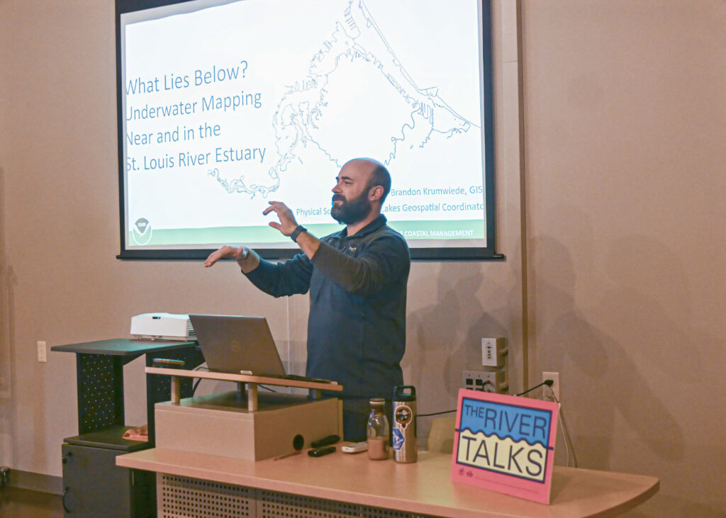
Brandon Krumwiede describes mapping projects during his River Talk. Image credit: Michael Anderson

By Lily Cartier, University of Minnesota Duluth

Knowledge of the oceans is more than a matter of curiosity, our very survival may hinge on it.

–President John F. Kennedy

While this inspiring quote is about the oceans, the same could be said about two waterbodies that we know and love locally: the St. Louis River and Lake Superior.

But how much do we really know about these waters? Brandon Krumwiede, a Great Lakes geospatial coordinator for the National Oceanic and Atmospheric Administration (NOAA), told listeners at the March River Talk held at the Lake Superior Estuarium in Superior that what lies at the bottom has largely been unknown and unmapped.

Krumwiede said that full-fledged mapping of the St. Louis River Estuary was not undertaken until 1943, driven by World War II and the importance of local ship-building and steel production.

“It was really important to map out the river and the estuary so that we had safe navigation, commerce could commence, and all the vessels that were being built in the Twin Ports could be shipped overseas,” Krumwiede said.

After that, estuary mapping efforts languished. Currently, there is not a comprehensive modern picture of the St. Louis River Estuary or the Great Lakes. It is difficult to know the health of the plants, animals and water in the area without knowing what lies below the surface. 

Along with an assortment of government and local agencies, NOAA gained funding from the Great Lakes Restoration Initiative in 2020 for a project called the Collaborative Benthic Habitat Mapping in the Nearshore Waters of the Great Lakes. The team uses benthic habitat mapping to measure the water levels in the Great Lakes. The goal is to map any part of the Great Lakes that has a depth of 80 meters or less. As of now, the project has mapped about 13% of the Great Lakes. 

This underwater mapping is done through two different methods. The first is called “sonar,” a process that uses sound waves to map the area. This uses small survey boats that move up and down the area that is mapped. The second is called “lidar,” which stands for light detection and ranging. This mapping technique uses green lasers on vessels or drones to map the substrate.

“At night, with a bathymetric lidar survey, you[‘ll] see this plane spinning around a green laser all over the beach. It looks like a UFO,” Krumwiede said.

Both types of underwater mapping come with pros and cons – the main one being the reliance on good weather while the data is taken. As you can imagine, lake conditions in northern Minnesota and Wisconsin are not often optimal for boats and small vessels. This study has a short season of about May to early November, at the latest. 

Krumwiede wished they would have prepared better for the warm weather we had this winter. “This season would have been amazing. We should have had survey boats here year-round because we were ice-free,” he said.

Why is mapping the river and Great Lakes vital? 

“It’s really important to think about, how do we ensure that we get the data that’s needed to make sure we make the right decisions and manage these natural resources into the future. For our generation and future generations down the road,” Krumwiede said.

The final River Talk for the season will be held at 6:30 p.m. on Wednesday, April 10, at the Lake Superior Estuarium. Keith Okeson with the Lake Superior Chapter of Muskies Inc., will present, “Muskies and the St. Louis River.”


The post Underwater mapping expands knowledge spanning from the St. Louis River to the Great Lakes first appeared on Wisconsin Sea Grant.
Original Article

Blog | Wisconsin Sea Grant

Blog | Wisconsin Sea Grant

https://www.seagrant.wisc.edu/blog/underwater-mapping-expands-knowledge-spanning-from-the-st-louis-river-to-the-great-lakes/

Wisconsin Sea Grant

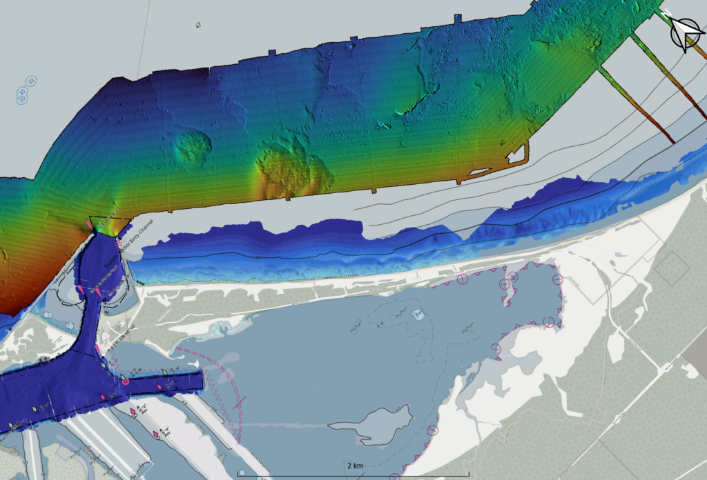
A map of the underwater substrate near the Superior Harbor Entry with Wisconsin Point in the middle, western Lake Superior. Image by Brandon Krumwiede, NOAA.

The next River Talk will be at 6:30 p.m. Wednesday, March 13, with “What Lies Below? Underwater Mapping Near and in the St. Louis River Estuary,” an in-person and virtual presentation by Brandon Krumwiede with the National Oceanic and Atmospheric Administration. His talk will be held at the Lake Superior Estuarium (3 Marina Dr., Superior, Wis.). Refreshments will be provided.

Brandon Krumwiede. Image credit: National Oceanic and Atmospheric Administration

Krumwiede’s work as a Great Lakes geospatial coordinator is varied and interesting. One day, he might analyze satellite data, the next, he might give a public presentation like River Talks. Krumwiede enjoys finding the connections between people, the land and the water. In his talk, Krumwiede will describe current efforts and technologies used to improve understanding of the underwater world near and in the estuary and its importance in coastal natural resources management.

To join by Zoom, please pre-register at this link:
https://uwmadison.zoom.us/meeting/register/tJcvcumrrj8vGNer4dHKwdZpxEoIVief60nR

For accessibility accommodations related to sound, language and translation, mobility or anything else to make engagement possible, please contact Luciana at 715-399-4085 or Luciana.Ranelli@wisc.edu, as soon as possible.

The final River Talk of the season will be held April 10. For more information, visit the River Talks page: go.wisc.edu/4uz720.

The River Talks are sponsored by the Lake Superior National Estuarine Research Reserve and the Wisconsin Sea Grant Program.


The post What Lies Below? Underwater Mapping first appeared on Wisconsin Sea Grant.

Original Article

News Releases | Wisconsin Sea Grant

News Releases | Wisconsin Sea Grant

https://www.seagrant.wisc.edu/news/what-lies-below-underwater-mapping/

Marie Zhuikov

The new season of River Talks began in October with two speakers who discussed the impacts of water level changes in the St. Louis River Estuary via Zoom. Brandon Krumwiede, Great Lakes geospatial coordinator with NOAA’s Office for Coastal Management, presented, “Water Level Change Impacts in the St. Louis River Estuary.” And Hannah Burgstaler, freshwater fellow at the Lake Superior National Estuarine Research Reserve, presented, “St. Louis River Estuary Water Level and Canada Geese Population Effect on Manoomin Survival Rate.”

Brandon Krumwiede. Submitted photo

Krumwiede described how water levels are changing in the Lake Superior Basin and then narrowed his scope to the estuary. “There’s been a huge step up in water levels in Lake Superior – a continual rise over the last several years, from 2007 to 2019. We’ve basically added three-and-a-half feet of water to the surface of Lake Superior,” Krumwiede said.

However, since August of 2020, levels in the basin have started to drop and are expected to continue to lower during the next six months. “Hopefully, this is that sigh of relief that everybody’s looking for with our recent exposure to high water levels,” Krumwiede said.

More locally, the estuary is sitting at or above record-high water levels. These can be exacerbated when wind from the northeast pushes water through the Wisconsin entry and the Duluth shipping canal. Krumwiede said urban stormwater runoff together with these northeast storm events can cause high water levels all the way to the Oliver Bridge (near Oliver, Wisconsin). He showed images of erosion on Allouez Bay, Wisconsin Point and Clough Island, along with inundated boat landings.

Low water levels can be problematic, too. “Often, in those new areas that are exposed, phragmites are some of the first species to take hold, so you have to deal with invasive species work,” he said. Access to the estuary for boaters can also be impeded.

For her research project, Burgstaler monitored four bays in the estuary (Allouez, Oliver-Little Pokegema, Duck Hunter South and Walleye Alley) using water pressure loggers and trail cameras, looking for the presence of geese and water levels that exceed a threshold for healthy wild rice growth. “Wild rice is at risk of completely disappearing in habitats where it once thrived. Factors contributing to its decline are fluctuating water levels, sulfide and mercury pollution, invasive species competition and waterfowl grazing,” Burgstaler said.

Hannah Burgstaler. Submitted photo

Wild rice tolerates a fluctuation range of up to six inches during the growing season and has a maximum water depth threshold of three feet. Continuous high water can “drown” the plants.

She visited the sites every one to two weeks by canoe, boat or paddleboard, to collect the camera SD cards and change batteries from June to September. She’s currently in the preliminary stages of data analysis. She’s going to compare her data with similar information collected by the Reserve and Fond du Lac Dam water release data to determine which sites are affected by seiches and water discharge from the dam. She will also compare geese counts in the different bays.

“Wild rice health is poor in the St. Louis River Estuary, but it’s still present so there’s still hope. From my preliminary data, geese may be negatively impacting wild rice survival with their browsing. Water levels in at least one bay exceeded 3 feet during the season and could impact wild rice survival. A combination of high water levels and geese may be contributing factors in the struggle of wild rice health in the St. Louis River Estuary,” Burgstaler said.

The Nov. 11 River Talk will feature Dustin Haines, research coordinator for the Reserve, who will present, “Should I Stay or Should I Go? The Clash of Wetlands With Lake Levels, Invasives and Humans.” His talk will also be via Zoom and held in cooperation with Café Scientifique Twin Ports. Join us at 7 pm:

https://uwmadison.zoom.us/j/97447413031?pwd=TkN2YjN5VGl0ODJtMWYzZGxCT2llUT09
Meeting ID: 974 4741 3031
Passcode: 424987

The post River Talk explores the impact of water levels on the St. Louis River Estuary first appeared on Wisconsin Sea Grant.

Original Article

Blog – Wisconsin Sea Grant

Blog – Wisconsin Sea Grant

https://www.seagrant.wisc.edu/blog/river-talk-explores-the-impact-of-water-levels-on-the-st-louis-river-estuary/

Marie Zhuikov

Quick, what do these things have in common: water level fluctuations, Canada goose populations and wild rice growth on the St. Louis River? Answer: they are all connected. Discover how they are linked during the first presentations of the season for the River Talks series.

Two speakers will offer virtual talks at 7 p.m. Wednesday, Oct. 14, via Zoom. Brandon Krumwiede, Great Lakes geospatial coordinator with NOAA’s Office for Coastal Management, will present, “Water Level Change Impacts in the St. Louis River Estuary.” Over the past several years, water level changes from near-record lows to near-record highs have altered the shorelines along Lake Superior and the estuary. Krumwiede’s presentation will provide an overview of the interplay between water levels and physical changes seen along the shorelines.

Hannah Burgstaler, freshwater fellow at the Lake Superior National Estuarine Research Reserve, will present, “St. Louis River Estuary Water Level and Canada Geese Population Effect on Manoomin Survival Rate.” Burgstaler monitored four bays using trail cameras, looking for the presence of geese and water levels that exceed a threshold for healthy wild rice growth.

Here is the Zoom link and info:
https://uwmadison.zoom.us/j/94136537051?pwd=OVk4QWpBODdIWUJaWkduQnYzREw0QT09
Meeting ID: 941 3653 7051
Passcode: 638298

Each talk will last one hour and include time for Q&A. The talks will be recorded and posted afterward on the Reserve’s Facebook page. A summary will also be posted on Wisconsin Sea Grant’s blog.

Other River Talks will be held Nov. 11, 2020, and Jan. 13, Feb. 10, March 3, April 14 and May 12, 2021. The March talk will be held in conjunction with the St. Louis River Summit and the date may change. For more information, visit the River Talks page: go.wisc.edu/4uz720.

River Talks are sponsored by The Lake Superior National Estuarine Research Reserve and the Wisconsin Sea Grant Program.

Original Article

News Releases – Wisconsin Sea Grant

News Releases – Wisconsin Sea Grant

https://www.seagrant.wisc.edu/news/water-levels-erosion-wild-rice-and-geese/

Marie Zhuikov